Large World Political wall map - with flags - 100*136
Product details
- Categories: EU Maps and Atlas
- Publisher: MAPS INTERNATIONAL
- ISBN: 9781903030486
- Binding: Paperback
Summary
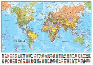
Maps International’s large world political wall map is simply stunning. Our large political world wall map comes with a panel of country flags along the base of the map. Perfect for helping children learn about the world and countries in the news.
Map details: Our large politically coloured world wall map features every country in a different colour, with country boundaries shown clearly. All major towns and cities are highlighted on our world wall map and capital cities are clearly shown. The map contains hill and sea shading bringing the map to life. The panel of flags along the base of the map and population facts and figures makes this map really interactive.
Map uses: As with most of our maps, the large world political wall map with flags, is available in a range of finishes making it suitable for a variety of locations.
One of our most popular world maps - educational and sensational looking! Perfect for classrooms, and for use in family rooms.
* Please note that the board mounted map, and board mounted and framed map are sized at 1210mm (w) x 890mm (h).